 We held our first WYLUG(ish) Open Street Map micro-mapping event on Sunday and it went well.
Six of us – me, John, Paul, Tim, Simon and Rob – went out mapping and then we went back to Dave’s afterwards to start turning the traces into maps.
It was the first OSM event I’ve organised but I had some advice from Tim (aka chippy) about timings etc and I think it worked out ok. We met for about half an hour to decide where we were all going and we decided on filling in some blank spots around East Leeds. I’d printed out maps and highlighted areas I thought needed attention, and once we’d double-checked no other speedy Leeds-er had filled in our selected spots between me printing the maps out in the early hours of Saturday and us meeting on Sunday afternoon, we headed out.
We headed out in pairs – John & I were in his car, the rest on foot – and traced for about two hours (including travelling there and back) before heading to Dave’s for the mapping part. As I mentioned the other day, the mapping software JOSM is rather hard to learn how to use so the hour-ish of mapping with experienced users Tim and Dave was really useful. I don’t think I’m an expert user now by any means but at least I can confidently do the most basic stuff like adding nodes and turning them into named, categorised ways without wanting to tear my hair out.
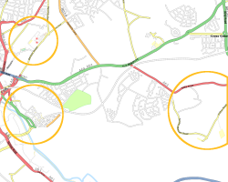
(The pics of the bits we’ve added from Sunday’s session so far, using the Osmarender view – click through for it on OSM.)
Lessons learned/Things to remember for next time
- The printed maps worked really well. I did some area overview ones and some more zoomed ones around the particular area that needed mapping. I think next time I’ll do some hyper-zoomed in ones for scribbling all over too instead of just using blank bits of paper. (Clipboards would be helpful for doing this.)
- Paul managed to lose his traces some how but could pretty much reconstruct them because he took waypoints (which didn’t delete) at every intersection. Our hacked TomTom is a pain for marking waypoints and so easy waypoint making is something I’ll definitely look out for if I buy a dedicated GPS unit.
- It was useful to have internet access at the initial meet session for double-checking the printed map data and it was essential to have internet access at the post-tracing session to download map data from OSM and to be able to access the reference parts of the Wiki.
- It was more time consuming to trace than I thought it would be – what with having to write down street names and everything – and the traces-to-maps is taking longer than I thought (although that’s because of JOSM problems and because I’ve been busy on other stuff since then, hello Oscars). Tim says we should allow about an hour for mapping time for every hour of tracing – and looking at the amount we did and the amount that’s already done of Leeds, I have to commend the people that have contributed before we got here. Thanks for doing so much already, lovely people :)
- Simon came over from Manchester after reading about it on a blog of a blog of a WYLUGer or something which made me realise if we organise another event – particularly the summer seaside day trips I’ve mentioned – we should publicise it more widely as people may be willing to travel for a hour for a day-long event. (Incidentally Rob came from Dewsbury and Paul from outside Huddersfield so thanks to all three for coming to contribute to evil Leeds’ map ;) )
- I should really have gone for a wee before I set off. Or not drunk a big glass of coke in the pub. Or taken some sort of receptacle.
- And on other forgotten human functions, we were all pretty hungry and thirsty by the time we finished too.
- We had a general WYLUG social afterwards (although it turned out to just be the mapping party plus people who had intended to map but couldn’t for whatever reason – Dave, Tom and Geoff) and we kept coming back to mapping issues amongst the general geeky talk – and I thought this review time was useful and interesting.
27/2/2008 at 2:49 am
Oh, and another lesson learned – edit the maps while they’re still fresh in your mind because it’s a lot easier to remember what each scrawl means then.
We’ve just done another big mapping session – an OSM date night around the major roads of south Bradford. So romantic. I’ve got most of that edited already – just have to wait until OSM comes back up to get the data to link it all in. Damn slashdot.
9/3/2008 at 9:59 pm
Sounds great.
If your up for another party come visit Durham in June :o)
http://wiki.openstreetmap.org/index.php/Durham_mapping_party