Categorylife

The general parent category for most of the things I write about on here.

One of the more interesting Louisa-centric sub-categories is biodata (where I explore my personal history with graphs, maps and whatnot), and if you’re that way inclined, you can read about the wonderful felines and canines with whom I’ve shared my life too.

All the words I’ve spoken* today

(* to another human, conversations with cats are excluded as they’re too verbose and frequently revoltingly soppy)

“Not while I’ve been here.”
“Dayrider please.”
“Thanks.”
“Just that please.”
“Thanks.”
“Thanks.”
“I don’t need a bag.”
“Thanks.”
“Just this.”
“Thanks.”
“No, thanks.”
“Do you go down Town Street?”
“Armley Town Street.”
“Thanks.”
“I’ll put the lemonade in here so that bag isn’t too heavy.” (Said bag split open anyway, shopping went everywhere, shitty Somerfield bags.)

Word count = 46
Thanks count = 7
Thanks/word ratio = 1:6.6

Open Street Map: micro-mapping party

Our new OSM additionsWe held our first WYLUG(ish) Open Street Map micro-mapping event on Sunday and it went well.

Six of us – me, John, Paul, Tim, Simon and Rob – went out mapping and then we went back to Dave’s afterwards to start turning the traces into maps.

It was the first OSM event I’ve organised but I had some advice from Tim (aka chippy) about timings etc and I think it worked out ok. We met for about half an hour to decide where we were all going and we decided on filling in some blank spots around East Leeds. I’d printed out maps and highlighted areas I thought needed attention, and once we’d double-checked no other speedy Leeds-er had filled in our selected spots between me printing the maps out in the early hours of Saturday and us meeting on Sunday afternoon, we headed out.

We headed out in pairs – John & I were in his car, the rest on foot – and traced for about two hours (including travelling there and back) before heading to Dave’s for the mapping part. As I mentioned the other day, the mapping software JOSM is rather hard to learn how to use so the hour-ish of mapping with experienced users Tim and Dave was really useful. I don’t think I’m an expert user now by any means but at least I can confidently do the most basic stuff like adding nodes and turning them into named, categorised ways without wanting to tear my hair out.

(The pics of the bits we’ve added from Sunday’s session so far, using the Osmarender view – click through for it on OSM.)

Lessons learned/Things to remember for next time

  • The printed maps worked really well. I did some area overview ones and some more zoomed ones around the particular area that needed mapping. I think next time I’ll do some hyper-zoomed in ones for scribbling all over too instead of just using blank bits of paper. (Clipboards would be helpful for doing this.)
  • Paul managed to lose his traces some how but could pretty much reconstruct them because he took waypoints (which didn’t delete) at every intersection. Our hacked TomTom is a pain for marking waypoints and so easy waypoint making is something I’ll definitely look out for if I buy a dedicated GPS unit.
  • It was useful to have internet access at the initial meet session for double-checking the printed map data and it was essential to have internet access at the post-tracing session to download map data from OSM and to be able to access the reference parts of the Wiki.
  • It was more time consuming to trace than I thought it would be – what with having to write down street names and everything – and the traces-to-maps is taking longer than I thought (although that’s because of JOSM problems and because I’ve been busy on other stuff since then, hello Oscars). Tim says we should allow about an hour for mapping time for every hour of tracing – and looking at the amount we did and the amount that’s already done of Leeds, I have to commend the people that have contributed before we got here. Thanks for doing so much already, lovely people :)
  • Simon came over from Manchester after reading about it on a blog of a blog of a WYLUGer or something which made me realise if we organise another event – particularly the summer seaside day trips I’ve mentioned – we should publicise it more widely as people may be willing to travel for a hour for a day-long event. (Incidentally Rob came from Dewsbury and Paul from outside Huddersfield so thanks to all three for coming to contribute to evil Leeds’ map ;) )
  • I should really have gone for a wee before I set off. Or not drunk a big glass of coke in the pub. Or taken some sort of receptacle.
  • And on other forgotten human functions, we were all pretty hungry and thirsty by the time we finished too.
  • We had a general WYLUG social afterwards (although it turned out to just be the mapping party plus people who had intended to map but couldn’t for whatever reason – Dave, Tom and Geoff) and we kept coming back to mapping issues amongst the general geeky talk – and I thought this review time was useful and interesting.

Open Street Mapping

OSM image for LeedsAfter an inspiring WYLUG talk about OpenStreetMap last Monday, John and I have decided to start mapping. John hacked our TomTom so it draws traces of our routes and we took a first test drive with it last night.

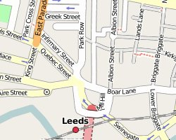
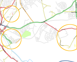
We drove around some of Armley’s main roads – most of it was already covered on OSM but we got a few new bits down and it was useful as a test exercise, seeing how our data linked up with the OSM data. Because we were driving, we had the trace thing to record a dot every second but it seems like it only did every 5-10seconds or so — which was a pain because we were moving comparatively fast. We also went over quite a wide area – from our estate in the middle of Armley, east to the near HMP Armley (about half a mile), then back along Tong Road and out towards New Farnley, then the outskirts on Pudsey and coming back through Bramley – so that made the size of our trace a bit too hard to handle for us newbs.

JOSM, the software we’re using to turn the traces into maps, was also a little harder to use than we would have liked. It is … quirky. Apparently it’s a very powerful tool once you get used to it and learn all the shortcuts but at the moment, to quote someone I just spoke to on #OSM, we’re alternating screaming and crying tears of joy.

Anyway, despite the hell that is JOSM, I drew up a couple of tiny residential roads near the prison last night and uploaded them to OSM – and they’re already visible on the Osmarender view. It’s not much of course but it’s a start. Today I traced my walk back from swimming (well, half of the walk because the TomTom was also being “quirky”) and I’ve added another three residential roads this evening. From small acorns do impressive free (as in freedom) mapping project grow.

I’ll walk different routes coming back from swimming until the whole of our bit of Armley is done but on a bigger scale, I want to help getting Bradford mapped and I’m planning mapping expeditions to Southport too since there is very, very little on there (just the railway line and that’s coincidentally very near my mum and dad’s house).

Am looking forward to being able to contribute – it reminds me of creating “much wanted” articles on random subjects (including Czech Airlines, suburbs of Leeds and Liverpool, and Eurovision) on Wikipedia in the early days. I very much hope that OSM will grow as hugely successful and popular as Wikipedia is today.

Sunset in Sunny Southport

We took a trip to Southport today for a day out and to see my mum’n’dad – and we got a lovely day for it for a change – sunny, crisp and clear.

We bought some books (including a cool photo one on human dissection), wandered around the town for a bit and ate some fresh donuts before strolling off down the pier in time for sunset – well, coincidentally being on the pier at sunset anyway. For once the sea looked to have been in to almost the sea wall in recent times so the dying sunlight reflected quite beautifully off the sand and I took some photos. I used the “Sundown” setting on my camera sometimes (the redder pictures) and the standard setting the rest of the time (the ones with the blue sky). I’m quite impressed by how my little camera managed it – as usual, all I’ve done to the photos is scale them – haven’t changed any colour levels or anything.

After all that perambulation of the pier, we went to the Guesthouse pub for John to try a Southport Brewery beer but they didn’t have any on so he had to have something from Blackburn or somewhere instead (he said it was still good). After that, we went home so Mum could make us some home-made chips (actually from potatoes and fried! such a novelty these days!) and we all watched some godawful thing that passed for Saturday night prime time TV.

Then John and I had a heated discussion about the welfare state, the role of government and the two-party political system in the car on the way home.

It was a good day.

(Manhattaners, aka Andrew: I took a picture of the majestic building and of the foyer through the letterbox – see the small Manhattans subset. I so wished I’d thought ahead and seen if I could have arranged to go inside… next time maybe. I also took a picture of the Back Bath Street roadside because we were passing and it felt it needed remembering since we forgot about the skipping at Christmas. Next time maybe for that too.)

New WYLUG group on Flickr

20080114-wylug-04Went to WYLUG tonight and since everyone was fiddling with EeePCs (or however it’s capped), I thought I’d grab some photos of the group at play. There were five of the machines in total flying around so I labelled it an EeeeeeeeeeeeeeePC session.

If I wasn’t already looking at paying out for a new laptop (suitable for use a desktop) in the near future, I suspect I’d be tempted by one of the Asus machines – but as it is, we’ll probably wait until the next generation (or so) before “investing” — let everyone else be bug testers first and wait until the manufacturers have “shared” their good ideas a bit.

Anyway, my real reason for posting this message is that I’ve uploaded the photos from tonight to my Flickr account (including one of a rude but happy Potato Guy) and set up a WYLUG Flickr group for sharing WYLUG snaps in the future. Doing that also reminded me to upload some photos I took at the summer social last year. Hopefully I’ll add more in the future.

Social awkwardness

When I moved to Leeds in May 2000, I made a friend through work. Actually, I made a number of friends through work – I made more friends in that the six months in that job than I did in the rest of my (five and a half) years at the university combined – but for the sake of this post, I’m thinking about one person in particular.

We weren’t bestest-best buds or anything but we had a laugh together. He used to hang out in my office quite a bit during the day, we’d sometimes have lunch together in the department’s senior common room and we went to the pub together from time to time on various department-related outings or celebrations. After I left, we continued to meet up every couple of months at pubs or department parties and the like until, eventually, other stuff got in the way and we drifted apart.

About three years later, I was walking through the university at the end of the day, heading the back way into town to avoid the crowds, when I saw someone that looked like this person coming the other way up the cliff of steps. Given a few years had passed and the turnover of people through the uni is so vast, I wasn’t sure if it was him so didn’t say anything to be on the safe side. Then I saw him again on another two occasions in quick succession – same place, same time – and I realised it definitely was my old friend — but by then I thought it would be weird to say hello or acknowledge him because I’d essentially just ignored him the first two times. Of course, since we then passed each other just about every night for months, it was as equally awkward continuing to not acknowledge each other.
Continue reading